Saturday, May 16, 2020

Fred Harvey Postcard Packet - 1946

 Postcard packets were popular in the 1940's and 1950's.  This one was mailed from Winslow January 29, 1946. Fred Harvey artist(s) and photographer(s) are unknown.
 Source of postcard packet:
https://www.ebay.com/itm/Vintage-Postcard-Souvenir-Folder-Arizona-Grand-Canyon-Navajo-Winslow-Train-pm45/333598991628


To view video rendition of this postcard packet see:
https://spark.adobe.com/video/mqsroj9kQDB82

Friday, May 15, 2020

Mule Pass captures Continental Divide

America's Continental Divide location is widely viewed as set in stone, so to speak.  Once upon a time, The Continental Divide morphed 100 miles east of its true course and took up residence in the Mule Mountains a few miles west of bustling Bisbee, Arizona.

For the better part of a generation everyone, including the federal government, believed The Continental Divide could be visited atop the challenging topography of Mule Pass.
Peter Corbett photo.

Today's savvy travelers guffaw at the antiquated notion Mule Pass split drainages of the Atlantic and Pacific Oceans.  Some folks even think it's an age old prank perhaps perpetuated by prisoners who helped transform a crude wagon road into a passable automobile route that eventually became highway US 80.

Harking back to the teens of the fledgling 20th Century, the nuances of geography and hydrology were scarcely known. People thought of the sprawling Lower Sonoran Desert landscape in broad Big Picture perspectives. The finer points of precisely where water flowed out in the far flung playas and dead end dry washes simply wasn't something people knew or cared about.

Meanwhile, the 6,030 foot elevation of Mule Pass was etched tall in everyone's mind.  To muleskinners hauling heavy loads to the Bisbee mining camps Mule Pass was a fearsome obstacle.  Even ordinary travelers harbored healthy respect for the steep-sided slopes of Mule Pass.  It was a place to be reckoned with.  Besides that, the route up and over Mule Pass was the highest point for hundreds of square miles around.

When the often outrageous monsoon storms pummeled the Mule Mountains, water rushed in torrents two ways off Mule Pass often swamping Bisbee with destructive and sometimes fatal results. Although the exact origins of Mule Pass as The Continental Divide are lost in the dust bin of history, it's reasonable speculation to presume local folks simply started calling the pass The Divide.  After all, it says so right on the topo map.

And so if it's The Divide, then why not The Continental Divide?  As far as local folks were concerned anything East of Bisbee was just a flat, gawd-forsaken desert that stretched to The Rio Grande at El Paso.
Sure enough when the feds created US 80 in the mid-1920's, the Bureau of Public Roads put out a 1927 news release describing the highway that said, "The road reaches the summit of the Continental Divide about three miles west of Bisbee, Arizona, at the Mule Pass - altitude 6,035 feet." Mule Pass was the highest point on US 80 from Savannah, Georgia, to San Diego, California.  What better site could there be to place The Continental Divide?

It was an accepted fact, even if it was off by over 100 miles. Former ADOT Public Information Officer Peter Corbett captured a quote that perfectly sums up how local folks felt about The Continental Divide's misplaced credentials: "Deloris Reynolds, Bisbee Mining & Historical Museum voluntary librarian, said she could find no evidence anyone ever tried to correct the mistake. “I suspect many (locals) did not know it was wrong and others probably didn’t care,” she said."

Modern visitors to Mule Pass justifiably roll their eyes and smirk at the stately stone monument marking The Continental Divide.  Considering the lack of knowledge and the "tenor of the times," such a misplaced belief is easy to understand and accept.

The actual location of The Continental Divide on old US 80 and today's I-10 is so obscure, so flat, so non-descript and so uninspiring as to be completely boring and unworthy of any attention from passersby.  As the majestic, soaring mountain crests that form The Continental Divide's iconic image in American mythology fade into the Lower Sonoran's vast expanse of desert scrub brush, so to does the actual dividing of the waters disappear in a jigsaw puzzle of playas and arroyos to nowhere.

As the author of the New Mexico Guide to the Continental Divide Trail says, ""The CDT's end, or beginning, will be, well, unassuming, at best.  Underwhelming, perhaps anticlimactic.  A wire fence, a dirt road, and miles of scrub and brush.  But that's okay. After all, on journeys such as these, the inner landscape is what's important."

It's little wonder that local folks and highway boosters bought into Mule Pass as The Continental Divide.  Why Not?  Who knew the difference?  And who cared?

We did quite a bit of study to compile numerous resources regarding Mule Pass and also the actual Continental Divide.  Commentary follows each photo or graphic below.

The first mention we can find of the Mule Pass monument is in a Page 9 article published September 6, 1914, by "The Bisbee Daily Review." Source: https://www.newspapers.com/clip/50938926/pulsating-machine-mule-pass/
Photo from Atlas Obscura. To read everything inscribed on monument see: https://www.hmdb.org/m.asp?m=48552
It was common practice in early highway days to use convicts on road construction jobs.  An unknown number of convicts converted a wagon route into what was then called "The Hanging Road" because of the difficulty of construction. Photo Source:
https://www.atlasobscura.com/places/mule-pass-not-quite-the-continental-divide


US 80 (and now I-10) actually crossed The Continental Divide at Separ, New Mexico, 100+ airline miles and ~143 highway miles from Mule Pass. App used to calculate distances:
https://www.mapdevelopers.com/distance_from_to.php
The far southern terminus of the CDT is located 100 airline miles practically due east of Mule Pass.  Finding this location appears to be a daunting challenge:

"Directions: To access the CDT’s southern terminus remote location take Interstate 10 east from Lordsburg, NM to Exit 49. Take NM 146 South to Hachita. In Hatchita, go east on NM 9 and then south on NM 81. Continue south for approximately 11 miles and just before the curve in the highway, turn left onto the graded dirt road (all roads beyond this point are dirt). Set your odometer, travel
approximately 3 miles, and turn right. Go another 3 miles and turn left. Follow this road around the base of the Big Hatchet Mountains for about 20 miles to a windmill and go east for 2 miles. Within 100 yards, you will be at the international boundary barbed wire fence. At the cattle guard, there is a
concrete monument commemorating the Crazy cook who murdered someone at this site. The Continental Divide National Scenic Trail is 200 yards north along the border fence from this monument." Source: https://continentaldividetrail.org/project/southern-terminus-of-continental-
divide-trail-and-the-big-hatchet-mountains/
Here is a view of the parking lot at the southern end of the CDT. For more location information see:
https://www.latlong.net/place/crazy-cook-monument-hachita-nm-usa-27705.html
Although the Hatchet Mountains are a prominent landmark on the horizon, the landscape upon which the Continental Divide sits is about as flat as flat can get.  Source:
https://en.wikipedia.org/wiki/Big_Hatchet_Mountains

The twisty-turny trip up and over Mule Pass was a thorn in the side of Bisbeeans practically since the first wagon load of supplies dropped down the steep slopes into the ragged gulches of a frontier mining camp. After decades of clamor, lobbying and numerous fatalities, the Arizona State Highway Dept. began a two-year tunnel project that was the largest Arizona highway construction project of its kind ever undertaken up to that time.
A 1,400 foot tunnel cut six miles off a trip over The Mule Mountains. The new tunnel was dedicated with much fanfare on December 19, 1958.  For coverage & details of the dedication see these links:

https://www.newspapers.com/clip/51103942/tucson-version-of-tunnel-dedication/
https://www.newspapers.com/clip/51102228/tunnel-dedication/
https://azdot.gov/adot-blog/mule-pass-tunnel-has-eased-trip-bisbee-60-years

To take a look at a drive through the tunnel see this find dash cam video by the Cochise County Sheriff's Office: https://www.facebook.com/watch/?v=543285556153613

This Google Earth screen clip shows how the tunnel was created almost directly underneath "The Continental Divide" of Mule Pass.  The left arrow shows old US 80 joining the modern day highway west of the tunnel.  Middle arrow is the location of The Mule Pass monument.  Right arrow shows how old US 80 came into Upper West Bisbee.
Interestingly, Mule Pass wasn't the only location to be mislabeled "Continental Divide."
"Near Victorio siding (named from the Apache chief referred to on p. 147), which is in the middle of the valley, the rounded slopes of the Cedar Grove Mountains extend along the north side of the valley, and the more rugged outlines of the Sierra Rica rise prominently to the southwest.22 About 1-1/2 miles west of Continental siding there is a sign reading "Continental Divide," but this is a mistake, as the basin of Hachita Creek, to the west, empties into the Rio Casas Grandes in Mexico, which, like other streams east to Arena, drains into Lake Guzman."

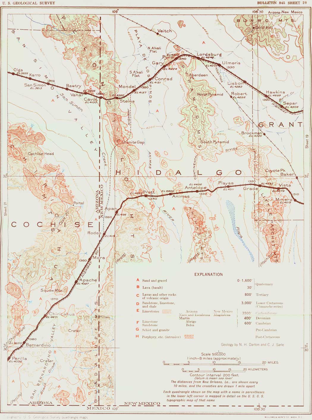
This same publication describes the old railroad crossing of the actual Divide:
"The Continental Divide is crossed on the inconspicuous summit a few miles west of Playas siding, at an elevation of about 4,515 feet. To the west of this point the drainage flows into the Animas River, which empties into the playas west of Lordsburg. These playas, on the rare occasions when they overflow, drain into the Gila River, which empties into the Colorado River and thus into the Gulf of
California."

Source: https://www.nps.gov/parkhistory/online_books/geology/publications/bul/845/images/sheet20.jpg

Photo source: https://www.atlasobscura.com/places/mule-pass-not-quite-the-continental-divide
In closing, we believe the Mule Pass Continental Divide monument to be a sparkling gem of early Arizona's road building legacy.  Engineers and managers at the time worked with what they had and used what they thought was the best available information.  They cannot be faulted for a egregious 100+ mile geography error.  They no doubt believed they "had it right."  Meanwhile, Mule Pass was and remains a wonderful location to actually ponder The Continental Divide. It's hard to imagine anyone getting excited about standing in a flat barren desert while contemplating water flowing to the oceans.
Mule Pass is definitely one of the more evocative, unique and noteworthy remaining attractions of old US 80's wildly winding route through Arizona.  It deserves attention and a visit from any highway heritage tourist.

Additional source information:

The photo at the top of this post is almost certainly a Burton Frasher picture.  It is framed in classic Frasher style and the handwriting on the photo easily matched that of other Bisbee photos by Frasher.  Chances are very good that the photo was created in the 1940's when Frasher was visiting Bisbee to record other images.  To see some of Frasher's Bisbee photos simply go to this link and enter "Bisbee, Arizona" without quote marks: https://calisphere.org/

To learn more about The Legendary Burton Frasher see:
http://content.ci.pomona.ca.us/index_frasher.php

Actual source of the postcard view used here is:
https://www.ebay.com/itm/Bisbee-Arizona-1940s-Continental-Divide-Top-RPPC-Photo-Postcard-Cook-11510/372860831054

Source of the CDT quote is from:
"New Mexico's Continental Divide Trail: The Official Guide" by Bob Julyan
Big Earth Publishing, 2001, 320 pages
https://books.google.com/books?id=Y4QGiYHpozwC

The U.S. Bureau of Public roads 1927 quote about the Mule Pass Continental Divide can be found here: https://www.fhwa.dot.gov/infrastructure/us80.cfm

Map clips were created using: https://ngmdb.usgs.gov/topoview/viewer/

Other source links are embedded in the post narrative itself.

For the US 80 Wiki see: https://en.wikipedia.org/wiki/U.S._Route_80

Note that on September 21, 2018 the Arizona Transportation Board designated the old alignment of US 80 as a state Historic Road connecting with the designation in California. The Tucson Historic Preservation Foundation led a six year battle to obtain the designation.  After the nomination was approved, Project leader Demion Clinco said: "“The designation of this uniquely American historic highway represents years of community advocacy and a long-term commitment of dozens of community groups and stakeholders."

We hope that someday soon, highway US 80 fans will seek to highlight and celebrate was has heretofore been a minor laughing stock atop Mule Pass.

Thank You for reading.  John Parsons, Editor.

Friday, April 3, 2020

AZ Memory Project Newspapers

This is a tutorial on how to use the AZ Memory Project's Digital Newspapers. We created this post to help anyone who might be daunted or confused by this rather larger database of old Arizona newspapers.  The very first to do is go to The AZ Memory Project: https://azmemory.azlibrary.gov/
Instructions are BELOW each screen capture.
 Once you click the AZ Memory Project link the screen above it what you will see.  Simply click the image for "Arizona Historical Digital Newspapers.
 The next screen you will see shows each of the Arizona Counties.  Pick you choice.  For this tutorial we used Pinal County.  Just click the County's name.
 The next screen will bring up all available digital copies of newspapers from that County. Bear in mind not all newspapers for any given County are digitized or available online.  This page will show you only what the AZ Memory Project has online.  In some counties there are many newspapers available so simply scroll down to find whichever newspaper interests you.  In this case we picked the "Arizona Weekly Enterprise" because we could see it was the oldest available Pinal County newspaper.  Simply click the link for the newspaper of your choice.
 Next you will see an excellent but short description of the history of that particular newspaper.  However, the important link is the large button that says "Browse and Search This Title.  Click that button.
Your next challenge is to pick a specific issue of the newspaper to browse and read.  The very earliest issues of "The Arizona Weekly Enterprise" are in very poor condition.  We therefore scrolled down until we found what looks like a clean copy of the newspaper.  It just so happened to be The April 1st, 1882, issue of "The Arizona Weekly Enterprise."  Naturally, click on the issue of your choice.
The next screen you will see shows Page 1 of the edition of your choice.  Obviously, you have a lot of choices on this screen.  The key choice is the button labeled "View." If you don't want to inspect Page 1, the other pages in this edition are in the right column and you can select any one of your choice.  Remember that for EACH page you bring you, you must press the "View" button.
Once you have pressed "View" then you can Zoom in for MUCH greater detail on any given page. The zoom feature is truly amazing! Zoom controls are faintly shown in the upper left of any given page.  I have found that I can also use the PC keyboard command "SHIFT +" and control the zoom increments to a finer degree than I can with the embedded zoom controls.
Now your individual challenge entails roaming around that issue of the newspaper of your choice looking for something that catches your attention.  In our case, we spotted this ad on Page 4 and then zoomed in on it.
This ad really caught our attention in a Big Way. So many things to ponder in this ad.  All of the classic questions: "Who, What, Where, Why, When & How?" come to mind when we see an ad such as this.  We'd never heard of "Butte, Arizona."

Once we find anything that captures our attention, we also capture it!  On our PC, we used the screen capture function.  Typically each PC had a slightly different keyboard command to enable a screen capture.  We use the freeware program "Irfanview" to crop and adjust the screen capture.  Many such programs and apps are available.

Of course, this is where the Real Fun begins!  How to answer all of our questions about Butte? 

We will write a separate blog post on the process (and journey) we followed to learn all about Butte.

Good Luck and Thanks for reading.  We certainly hope that you share whatever you find and investigate with the Facebook history group(s) of your preference(s).

Sincerely, John Parsons, Rimrock, Arizona

Sunday, January 12, 2020

The Two Spot

Photo by Peter Corbett  http://www.ontheroadarizona.com/

The Two Spot is a beloved Flagstaff icon that sits serenely on the southeast corner of the bustling intersection of Route 66 and San Francisco Street. Probably everyone who lives in or visits Flagstaff is aware of the engine but how many know it's name?

It's The Two Spot!


And, believe it or not, The Two Spot is actually on The National Register of Historic Places.
The Two Spot is steam locomotive #35938 that was constructed in 1910 and early 1911 by the Baldwin Locomotive Works (BLW) of Philadelphia, Pennsylvania, for the Arizona Lumber Timber Company (AL&T) of Flagstaff, Arizona. The locomotive bore the number "25" in the AL&T roster. It was called Two Spot because water bag hanging from its cab obscured and eventually obliterated the number "5" and also because later owners changed its roster number to "2." The standard gauge 2-8-0 steam locomotive was used 55 years by the AL&T, the Saginaw Manistee Lumber Company, Southwest Lumber Mills, and Southwest Forest Industries for operations in the Flagstaff area until being retired from service in 1966.

Baldwin Locomotive Works/BLW began building the oil-powered steam engine with tender in 1910, completed it in January of 1911, and outshipped it on January 20, 1911.  Mr. Taylor was the engineer in charge of the cross-country delivery. The AL&T received the locomotive in February and immediately placed #25 in service at the newly-rebuilt Greenlaw mill. Pleased with his purchase, Timothy A. Riordan remitted payment of $11,220 to BLW on April 19,1911.

Once hallmark of the lumber industry, logging trains such as Two Spot are now extremely rare. The report "Logging Railroad Resources of the Coconino and Kaibab National Forests, Arizona" estimated that about 30 logging locomotives operated at various times (circa 1887 to 1966) in the greater Flagstaff area. Most were sold for scrap iron during World War II. Only two Baldwin #35938 and #60870 have survived to the present day. Of the two, #35938 is the older, predating #60870 by 18 years; #35938 is, in fact, the only surviving pre-World War logging locomotive left in the Flagstaff area. The structure accurately reflects the engineering and configuration of Consolidation 2-8-0 engine of Baldwin class 10-30 E, once common but now rare type. With its steam-powered locomotive, tender, and log carrier car, Two Spot embodies the distinctive design characteristics of a technology that is now obsolete.

In its order and drawing system, BLW referred to the Flagstaff engine as "10-30 123." The code translated as follows: "10" was the total number of wheels; "30" was code for the cylinder diameter; in this case it meant 18-inch diameter cylinders; "E" referred to four pairs of driving wheels; and "123" was the sequence number in the class; that is, the AL&T locomotive was the 123rd example of this class. Class 10-30 E was light-to-medium weight freight locomotive of the period. It made solid narrow-gauge freight hauler, as demonstrated by the 50 examples that BLW sold to the Japanese mainline railways. It was also popular in standard gauge, version used in constructing the El Paso Southwestern from Bisbee to El Paso. In terms of wheel arrangement, Baldwin #35938 was Consolidation 2-8-0 type locomotive, meaning that it had one pair of pilot (truck) wheels, four pair of drive wheels, and no trailing axle wheels.

Locomotive #25 first acquired its more common name of "Two Spot" because its engineers used to suspend from the cab  a water bag that obscured and eventually obliterated the number "5". Around 1951 Saginaw Manistee renumbered the engine as "2," the number it retained under subsequent Southwest Lumber and Southwest Forest ownership. The engine has since been repainted with its original AL&T roster number of "25."

The above information was extracted from the National Register nomination located here:
https://ncptt.nps.gov/rt66/wp-content/uploads/2012/09/TwoSpotLoggingTrain_Flagstaff_AZ.pdf
The nomination document contains much additional information.

Many Thanks to Peter Corbett for recording these images to make this post possible.

Photo by Peter Corbett  http://www.ontheroadarizona.com/

Wednesday, January 8, 2020

Toll Road to Nowhere

Virtually everyone in Flagstaff has at least heard mention of the legendary name "Weatherford." Uncounted tens of thousands of people have passed by or enjoyed the hospitality of downtown's historic Weatherford Hotel.  As time passes and newcomers flood into Flagstaff, Weatherford's other big project fades fast into obscurity. 

Even those who might chance to hike all or a portion of The Weatherford Trail #102 may not fully know the Story of The San Francisco Scenic Mountain Boulevard, an expensive pipe dream that turned into a road to nowhere.  This post attempts to give a brief overview of the road.  James Babbitt wrote a definitive discussion of the project and his work is cited at the end of this post.

Source of photo:
https://www.worthpoint.com/worthopedia/flagstaff-az-san-francisco-scenic-1809912940
The San Francisco Scenic Mountain Boulevard had an average grade of 8 % with maximum grades of 11%.  It's hairpin switchbacks can still clearly be seen on Google Earth.

Source of photo:
https://www.worthpoint.com/worthopedia/arizona-mountain-boulevard-flagstaff-2017046023

John W. Weatherford was born October 24, 1859, in Weatherford, Texas.  He arrived in Flagstaff in 1887 and promptly made a major difference in the community by building a large hotel which remains a beloved Flagstaff lodging landmark and legendary watering hole.  In 1895, Weatherford rode a horse to the top of the Peaks and that's when the glimmer of an idea for a future toll road first took hold.  Success of the Pike's Peak toll road further captured Weatherford's attention and in 1915 he applied for a permit from the Forest Service to build a similar road to the top of The San Francisco Peaks. 

(Adapted from source: https://www.jstor.org/stable/41696969 See note at end of post.)

Source of Weatherford photo:
http://archive.library.nau.edu/digital/collection/cpa/id/11223/rec/1

After much bureaucratic wrangling, Weather had his permit in hand by May 1916. He incorporated the San Francisco Scenic Mountain Boulevard Company in August 1917 and tried to sell stock.  The stock idea didn't go over well in Flagstaff or anywhere else but Weatherford forged ahead.  Construction eventually began in 1920 with completion of the first two miles of the road. 

(Adapted from source: https://www.jstor.org/stable/41696969 See note at end of post.)

Source of stock certificate image:
http://library.nau.edu/speccoll/exhibits/sca/collect/manusrpt/sf.html

"Nevertheless, work continued during the summer months of 1921, 1922, and 1923. By the spring of 1924, some seven miles of road had been completed. On June 9, a group of prominent Flagstaff businessmen that included Tim Riordan, E. A. Haight, K. J. Nackard, and David Babbitt drove over the completed portion of the route. They enthusiastically endorsed the project." 

(Adapted from source: https://www.jstor.org/stable/41696969 See note at end of post.)

Source of photo:
https://www.worthpoint.com/worthopedia/flagstaff-az-san-francisco-scenic-1809912940

We were roaming eBay on January 8, 2020 looking at new listings under the category "Flagstaff postcard" when we found three views of the San Francisco Scenic Mountain Boulevard.  Although we first heard of the road in 1980 as "The Weatherford Road," we had never looked into the subject.  Today's post is a result of the chance finding of those three views on eBay. The three views include this one and the next two below.

Source of photo:
https://www.ebay.com/itm/Flagstaff-Arizona-San-Francisco-Peaks-Mountain-hand-colored-1920s-Postcard-13153/372903181332
By mid-1926, construction crews had completed 10.4 miles of steep, narrow road to the Fremont Saddle-enough for Weather ford to stage a grand opening ceremony. At 9:30 on the morning of August 19, local drivers lined up on Leroux Street, as Boy Scouts distributed souvenirs of the occasion. Some 170 automobiles made the trip to Fremont Saddle, where Flagstaff I.O.O.F. lodge members served a picnic luncheon. Dr. Earl Slipher of Lowell Observatory set up a telescope at the end of the road that allowed sightseers to gaze over the Grand Canyon and into six different states." 

(Adapted from source: https://www.jstor.org/stable/41696969 See note at end of post.)

Source of photo:
https://www.ebay.com/itm/Flagstaff-Arizona-Hand-Colored-1920s-Postcard-San-Francisco-Mountain-13162/402026291566
The stock market crash of 1929 put a permanent damper on both use and lengthening of the road.  Weatherford died January 7, 1934.  The Forest Service revoked the special use permit January 19, 1938.  Altogether, $150,000 was purported to have been spent on the road. 

(Adapted from source: https://www.jstor.org/stable/41696969 See note at end of post.)

Source of photo:


Weatherford's widow and possibly some early investors pushed a claim of $15,500 from the federal government.  In 1939 President Roosevelt weighed in against such a claim. However, after much more bureaucratic and political wranglings, the claim was approved in June 1942.  Investors received a whisker more than seven cents for each share of stock they owned. 

(Adapted from source: https://www.jstor.org/stable/41696969 See note at end of post.)

The link below this screen clip goes to a more or less complete official account of how the $15,500 claim was finally reimbursed.
http://bit.ly/36DAI1Y


Perhaps the most notable use of Weatherford's old road to nowhere is the annual War Dog Race each October.  Northern Arizona Trail Runners Association members and guests climb 3,000 feet to Doyle Saddle along the rock strewn old right of way and then return for a total of 15 miles. The Way Dog event began in 1981, just three years before creation of the federal Kachina Peaks Wilderness area.

The steep trail continues to attract more hikers each year as visitors venture out to enjoy the splendor of The San Francisco Peak while pondering a piece of bygone history about a road to nowhere.

Here is a very thorough history of the War Dog. The photos here were taken from a slideshow at this link:
https://www.natra.org/history

Here's a great 10+ minute video of the 2012 War Dog with an account of its founding:
https://youtu.be/AWABn-B0W4g

The photo below showing War Dog runners on the old Weatherford Road gives a good idea of what that route must have looked like for early autoists and wagoneers traveling the steep grade up to Doyle Saddle and back.

NOTE: Any narrative in quotes above was taken directly from the source shown here and is believed to be within the Fair Use guidelines of U.S. Copyright Law.  All other narrative regarding the Weatherford Road is adapted in our own words from content in the source below and is likewise believed to be within Fair Use guidelines of U.S. Copyright Law.  Mr. Babbitt's article on the Weatherford Road is quite likely to be the best and definitive assessment of the subject.

Babbitt, James E. “THE IMPASSIBLE DREAM: John W. Weatherford's San Francisco Mountain Boulevard.” The Journal of Arizona History, vol. 47, no. 2, 2006, pp. 173–184. JSTOR, www.jstor.org/stable/41696969

Note: Mr. Babbitt's article states the Kachina Peaks Wilderness was designated in 1978.  It was designated in 1984. See: https://wilderness.net/visit-wilderness/?ID=285